NavigationHow does a spacecraft change course? |
Triangulation is a way of determining something's location using the locations of other things. It is commonly used by geologists to find the locations of Earthquakes, and is also used to determine spacecraft location. There are several ways to use triangulation to figure out location. Here's how it works.
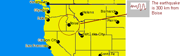
Earthquakes give off two kinds of waves. One kind is always faster than the other. The longer distance the waves travel, the more "ahead" the faster kind gets. If a place feels both kinds of Earthquake waves, it can figure out how far away the center of the Earthquake was. In the picture below, the waves tell scientists that the quake was 300 km away from Boise. Scientists can then draw a circle around Boise so that every point on the circle is 300 km from Boise. The Earthquake is somewhere on that circle.
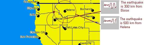
Other cities near Boise can also tell how far away the quake was. The quake is 500 km from Helena, so the scientists draw a 500 km radius circle around Helena. The Helena and Boise circles meet in two places. One of those was where the Earthquake happened.
To decide between the two, a third station is needed. The distance between the third station and the Earthquake is used to figure out where the Earthquake happened. The quake is 150 km from Salt Lake City. A circle around Salt Lake City hits one of the two dots and that tells us where the Earthquake is.

Earthquake triangulation uses the distance to something and figures out the exact location from that. Another kind of triangulation uses the direction to something to figure out location. Hikers can use radio waves to triangulate their location. A radio transmitter sends out waves from one location in all directions. A receiver will be loudest when the hiker is facing the transmitter. When the hiker knows the readings from two places, they can find the transmitter.


DS1's AutoNav system uses triangulation and the locations of asteroids in space to figure out its exact location.
![]()
How do we know a spacecraft's location?
What are radio waves?
![]()
![]()